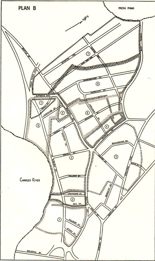
Earliest source: William L. Payson. "Notes on Some Tory Row Land Titles." The Proceedings of the Cambridge Historical Society vol. 37. 29 January 1957.toryrow
This map is actually from 1957 (I think), but it documents the Tory Row estates in the pre-Revolutionary War period. The area marked as number 3 (both sides of brattle with the lighter broken-line boundaries) is the estate of John Vassal. The observatory grounds are all the way to the right above Bond St. (the rightmost street with a label on it). According to this source, which admits to not being entirely thorough, the Vassal estate covered one corner of the Summer-house hill, eventually the obseratory. I think the line here would include the summit, where the Summer House stood, but it's not entirely clear.
Note that the streets are as they existed in 1957, not 1775. I don't think Bond Street existed at all until the Observatory was built, and if it did, would have had a different name. Likewise, Craigie Street wouldn't have had that name.
Vasall was loyal to the crown, and chose the wrong side when the Revolutionary War started. He fled and the Commonwealth seized the property. George Washington used his home as his headquarters for a year in 1775-76. The Commonwealth eventually sold the estate, and after changing hands a couple of times, it was sold to pharmacist and investor, Andrew Craigie. Craigie was both unwise and corrupt in his investments, and by the end of his life wouldn't leave his home for fear of arrest. He died of a stroke in 1819. His wife Elizabeth rented out rooms to cover his debt, until her death in 1841. Harvard purchased the Obsevatory grounds just a few months later from Craigie's heirs, grandchildren of his sisters (both from the same husband, Bossenger Foster (serially)).

Summerhouse hill, before it was Observatory Hill and before the Observatory existed at all. At this point it was owned by Andrew Craigie who's heirs would eventually sell it to the observatory.
Andrew Craigie, in addition to being a corrupt politician, was also a great innovator. He was one of the earliest people to build a greenhouse, even though it was considered unnatural by many at the time. He was also an early adopter of the concept of an ice-house. And it was built underneath his summerhouse, where early excavations for the Observatory would find signs of its existence.
From Charles Saunders' mathematical thesis.
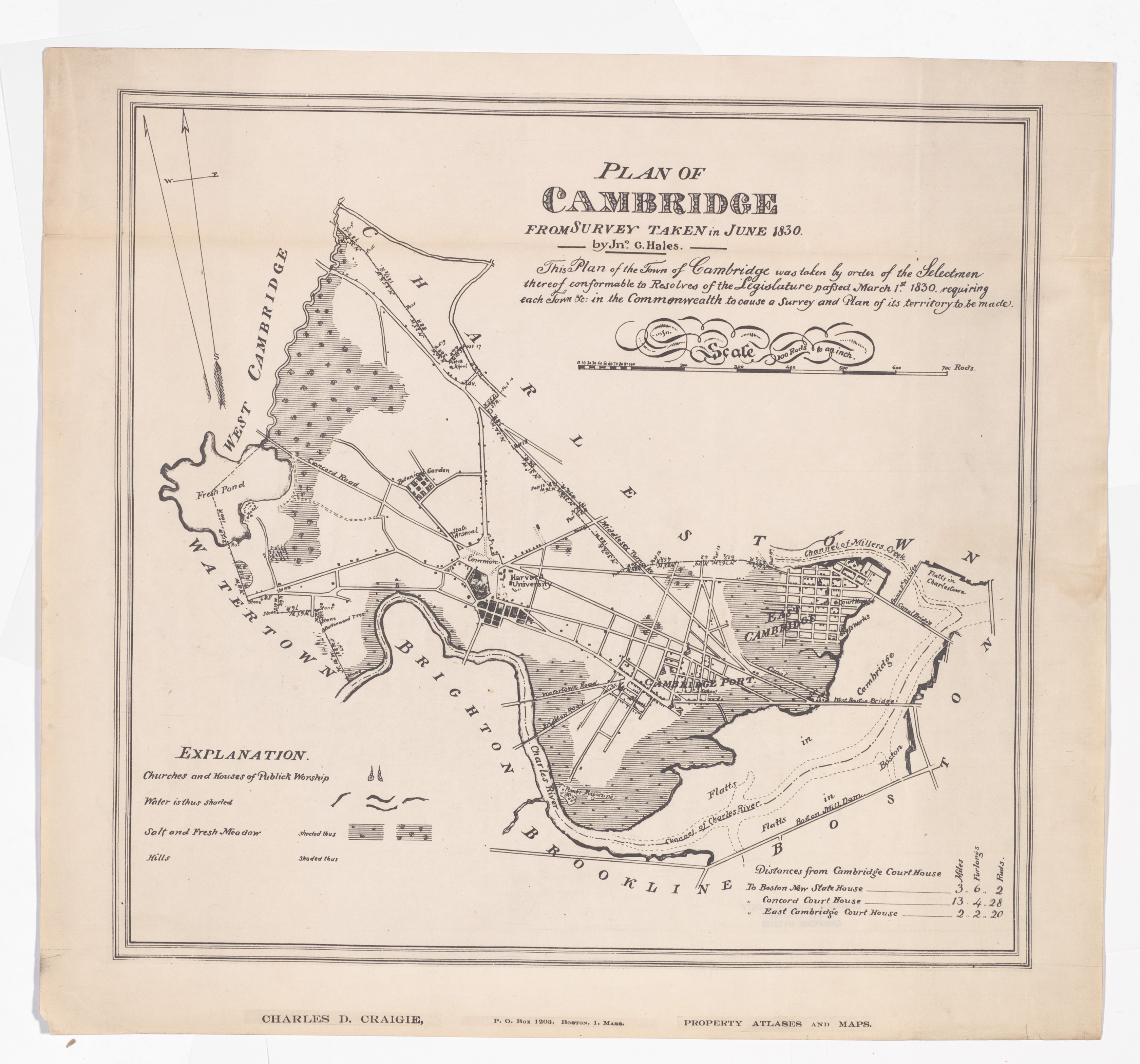
An 1830 map of Cambridge. The area the observatory will occupy is across the street from the Botanical Garden (for which Garden Street was named) and to the south. None of the cross streets from Graden to Concord are show except for what is now Huron. I'm assuming they were not actually there at the time. The structure on Summerhouse Hill would be in this area, but is not shown.
It's possible the summer house was already gone at this point. When the Observatory was built in 1844, it was apparently a surprise discovery that they were building on the old foundation of the summer house (on the ice-storage basement).
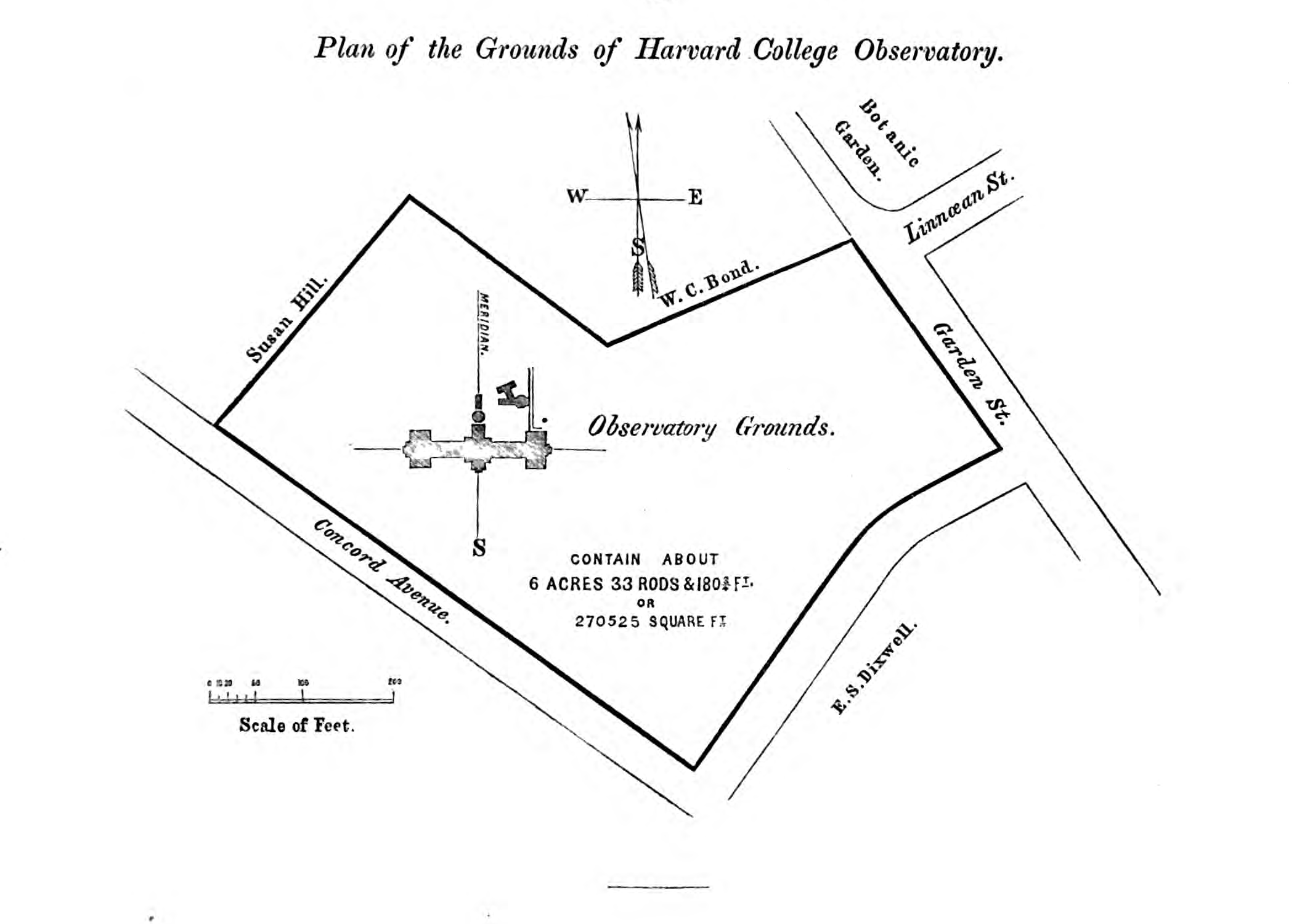
Earliest source: William Cranch Bond. Annals of the Astronomical Observatory of Harvard College / History and Description of the Astronomical Observatory of Harvard College vol. 1. Metcalf and Company, 1856.annals1
Earliest plan (found so far) of the observatory property, one year after the buildings were (mostly) completed. Other sources date this diagram to 1845
Still several areas for further research here.
When was Bond Street to the south named? Perhaps already, as it was likely done as a memorial to the son who died in 1841, rather than the director.
Was Madison Street (to the northeast, where it says "Susan Hill") already there? Other maps are unclear, the lack of a street doesn't mean it wasn't there, and one map I've seen has two parallel streets there before Huron (which was then Wyeth).
Was this before or after a land purchase from Susan Hill? Did they buy only part?
What was the old property line between Craigie/Foster heirs, and the other seller (Hill?)?
Where's the rest of the acreage? In the attached notes, it says that the university purchased 484,605 square feet from the Foster heirs (Craigie's sisters' descendants). But the drawn property is only 270,525 square feet. Also, it says that 62,271 square feet were purchased from Miss Hill. And elsewhere Harvard records indicate that part of the land they bought was then resold, for $600 (out of a total land purchase cost of $8288.85 according to this Annals).
When did the University buy additional property lablelled here as "W.C. Bond" (and was that the father or son?). A portion here was later purchased by Harvard from Selina Bond, the director's daughter, to expand the Observatory grounds to the modern borders.
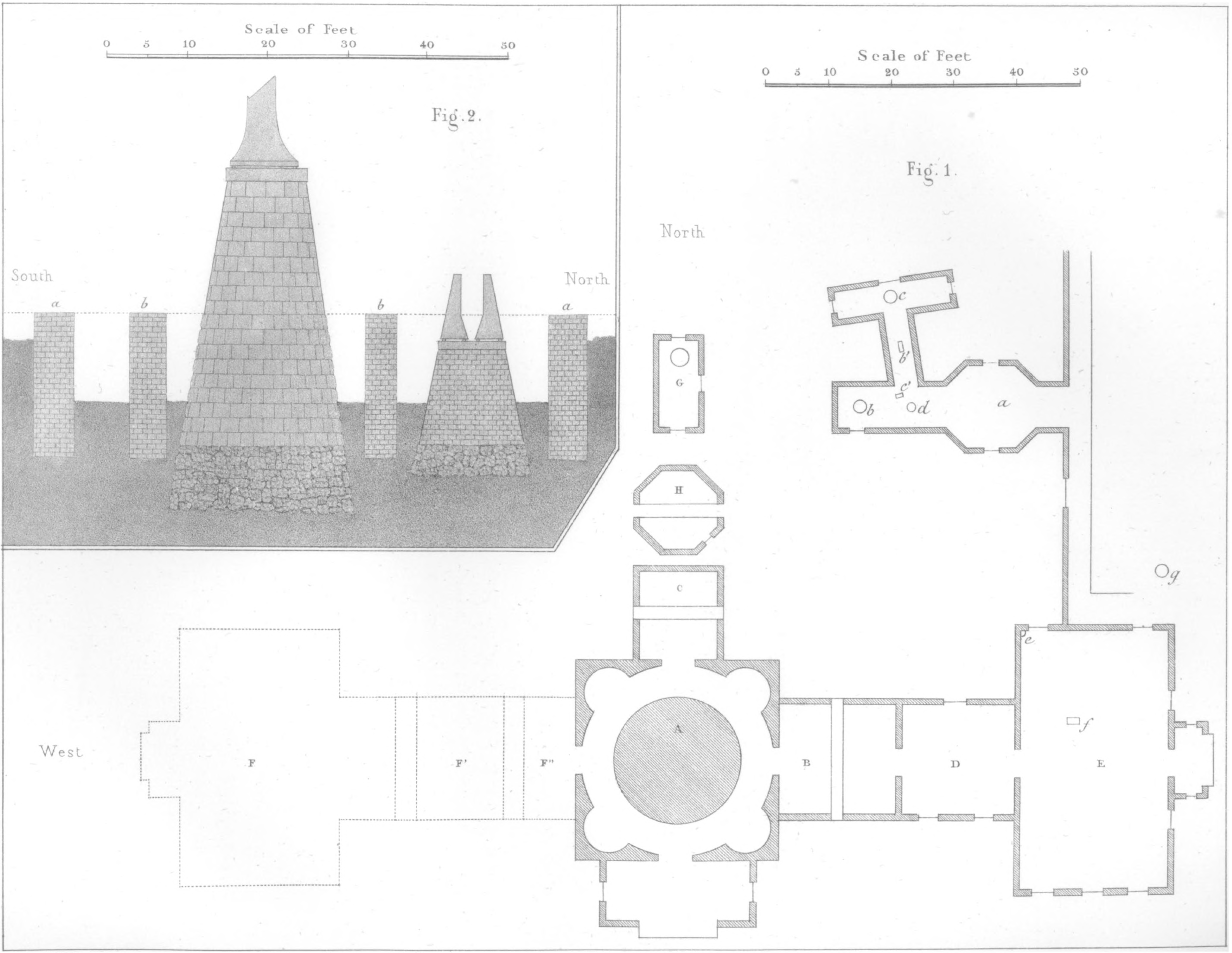
Earliest source: William Cranch Bond. "Description of the Observatory at Cambridge." Memoirs of the American Academy of Arts and Sciences vol. 4. Metcalf and Company, 1849.academybond
Earliest found plan of the observatory so far. Here are the descriptions found in this book:
Plate I., Fig. 1, is a ground plan of the principal buidings and of those appropriated to magnetc and meteorological purposes; at
A is the equatorial room and pier.
B, The transit-circle room.
C, The prime-vertical apartment.
In the smaller buildings,
a. The situation of the four-foot meridian-transit instrument.
b, The horizontal-force magnetometer.
c. The declination magnetometer.
b' and c', The reading telescopes of the magnetometers.
d, The small altitude and azimuth instrument.
In the construction of the buildings which protect the magnetic instruments, iron has been entirely excluded.
The wires connecting with a system of magnetic-telegraph lines, extending to most of the principal cities of the United States, are brought into the building containing the four-foot transit instrument, at a.
e is the situation of the standard barometer, made by Newman.
f, The transit or sidereal clock.
g, The deep well, for temperature of the earth at different depths below the surface.
G is a building used for miscellaneous purposes, chiefly for observation of the magnetic inclination; no iron was used in its construction.
H, The smaller prime-vertical room.
D, The computing room.
E, The observer's dwelling-house.
The western wing, indicated by dotted lines at F, F', F'', is not yet built.
Plate I., Fig. 2, is a north and south section of the foundations of the walls of the equatorial and prime-vertical rooms, and of their respective piers; at a a are the foundatons of the outer walls, and at b b those of the inner walls; the latter support the dome.

Image Credit: H. F. Walling
Map of Cambridge from 1854. A rough outline of the observatory is shown on the grounds, along with a drive which used to connect Garden Street to Concord Avenue. Bond Street is not labelled with a name. Farther up Garden Street, we can see a home labelled "G. P. Bond". This would be George Phillip Bond, future director and one of the son of the director at that time, William Cranch Bond (who would have been living in the residence on Observatory property).
I've seen indications elsewhere that Bond St. was named in 1842, which seems off. However one of the director's sons, William Cranch Jr., died in 1842, and it may be that the street was named after him.
It doesn't show the borders of the Observatory property, but Harvard did not own all the way to Huron Ave (called Vassal Lane on this map). The southwest part of the property extended to what we now call Madison Street (not shown, but I've seen it in an 1852 map), but the northwest did not. The Observatory later purchased part of the northwest corner from Selina Bond (which seems suspicious to me, but I haven't looked into it yet).
Earliest source: William Cranch Bond. Annals of the Astronomical Observatory of Harvard College / History and Description of the Astronomical Observatory of Harvard College vol. 1. Metcalf and Company, 1856.annals1
Similar diagram to the 1848 verson, with different labels.
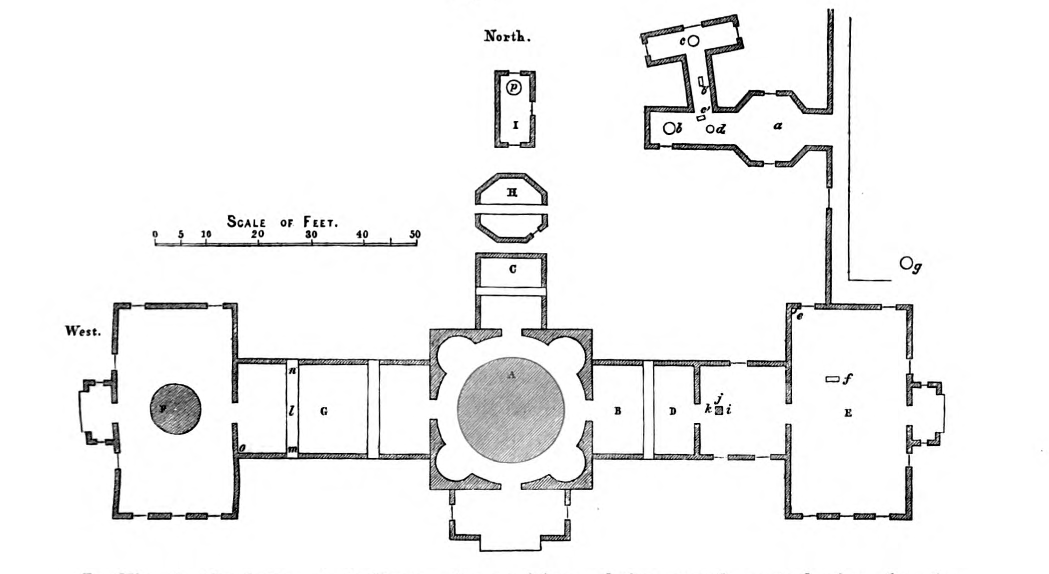
Earliest source: [Joseph Winlock and Arthur Searle?]. Annals of the Astronomical Observatory of Harvard College vol. 8. John Wilson and Son, October 1876.annals8
Plan of Observatory Grounds, and basic building plan. The west wing of the main observatory has had "alcoves added to receive the collimators of the Meridian Circle". The "Magnetic Observatory" building has been completed since the last plan we have on file (1845, above). Glimpses of this building are visible in later photos from 1887 and 1888. At first I thought this might be the location of the photographic enlarging room, as it closely matches the description in Annals32.annals32p1 However the 1888 Draper Report indicates the enlarging room was in a cottage where many photos of the Observatory were taken, and where the telegraph lines ran.draperreport1888 This is apparently not the building shown in the corner here with telegraph lines going to it, as the angles don't line up. with the photos. That cottage seems to be off of the property, on Madison Street (although that is now our property, as a parking lot).
The 1876 report where this plan was included indicates that some of the smaller buildings have been torn down. The building previously called a smaller prime veritcal room is already missing in this newer diagram. Between 1869 and 1876, the report further states that the unlabelled building north of the Great Rerfractor (G, East Equatorial) and I Prime vertical has been removed. Also removed are the set of odd shaped rooms labelled S here jutting out from R the Magnetic Observatory.
Note that the 1876 report refers to a building diagram in the 1855 report, which is identical in form to the one I have above from 1845, but with different lettering. The 1876 report also includes floor-by-floor building plans, lablelled with words rather than letters (included just above or below this one).
The telegraph lines go to a building where an observation deck was constructed, and many later photos were taken there.
Note that the grounds seem bigger in 1876 than in 1845. The Annals are a bit confusing on this point. If I interpret things correctly, the additional space northwest of the driveway used to belong to W.C. Bond (the father or the deceased son), and was purchased by the University form Selina Bond (by Director Joseph Winlock) in 1869, but by 1876, no changes to the grounds had been made. This plot of land would later hold Tennis courts which remain there (in updated form) today.
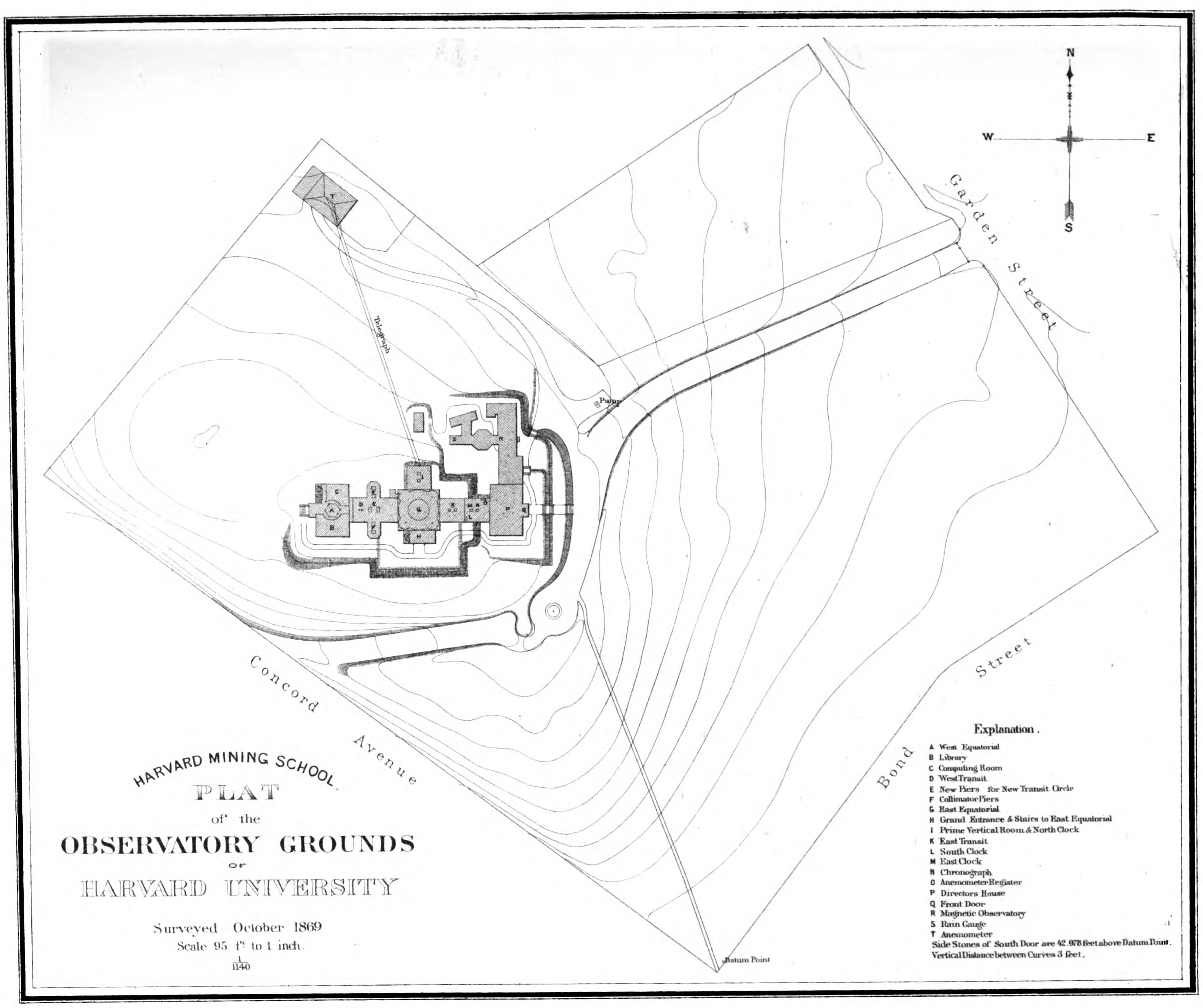
Earliest source: F. O. Vaille and H. A. Clark (Class of 1874). The Harvard Book / A Series of Historical, Biographical, and Descriptive Sketches vol. 1. Welch, Bigelow, and Company, 1875.harvardbook
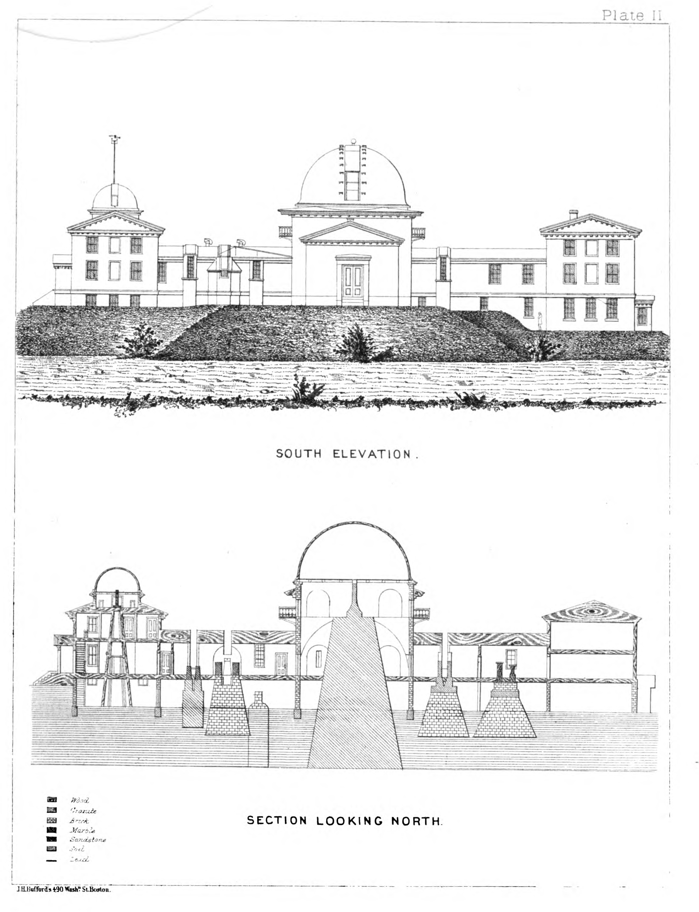
Source for this image: [Joseph Winlock and Arthur Searle?]. Annals of the Astronomical Observatory of Harvard College vol. 8. John Wilson and Son, October 1876.annals8
Elevation of the original observatory, as modified by 1876. The left transit circle room as been expanded with alcoves on either side.
The cutaway shows the piers for the instruments in the observatory. The largest pier is for the great refractor. To it's right is a pier for one of the transit circles, and further to the right is a pier that was used for clocks and [something else].
To the left of the large pier is what the Annals describe thusly: "the deep pit indicated just to the right of the pier of the Meridian Circle shows the place of an excavation intended by Professor Bond for experiements with a standard pendulum, but found to be too damp for that purpose."
To it's left is the pier for the other transit circle. This pier appears to be new since 1844. The original plan shows two separate transit instruments in this wing, but they are equally spaced along the wing. You can still see signs of both openings in this elevation. But the new meridian circle pier is smack in the middle of the west wing. I haven't yet read abou this change.
All the to the left is the pier for the west equatorial. This is far less substantial than the other piers, apparently made of wood. After water was provided to the west wing in 1869, the pier also housed a resevoir of water for use in case of a fire. The west equatorial telescope was replaced in 1868, the original being mounted as a finder telescope on the Great Refractor. In 1870 the west equatorial dome was converted from cloth to metal.
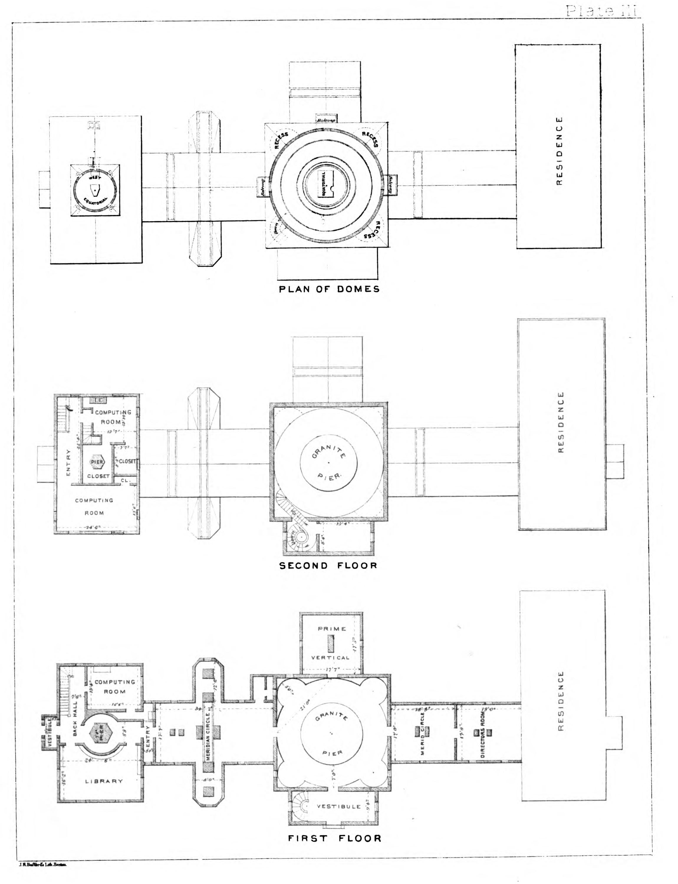
Earliest source: F. O. Vaille and H. A. Clark (Class of 1874). The Harvard Book / A Series of Historical, Biographical, and Descriptive Sketches vol. 1. Welch, Bigelow, and Company, 1875.harvardbook
Source for this image: [Joseph Winlock and Arthur Searle?]. Annals of the Astronomical Observatory of Harvard College vol. 8. John Wilson and Son, October 1876.annals8
These are the best floor plans I have for the observatory. Note that the Director's Residence is a black hole—I guess the rooms there were private and not our business. Incidentally, in 1867 the directors residence got running water.
One of the more significant changes is that the room next to the residence, in some earlier plans referred to as the computing room, is now the Director's room. This room also housed clocks, telegraph wiring, and other odd instruments. Rooms in the west wing had always been planned as offices or computing rooms, but this wing was unheated until sometime after 1866. With the addition of heat, and instulation, and repairs to leaky roofs and such, four additional rooms became available as computing rooms in the west wing, freeing up the director's room for whatever the director wanted to do with it. It's my belief that many of the older photographs of women computers are in one of these rooms in the west wing, as the images don't correlate to any rooms in the newer brick buildings, in particular the slightly arched ceiling.
The Prime Vertical was no longer in place, and the shutters had been sealed shut against the rain. This instrument was apparently important only for a precise determination of the observatory's position, and this having been accomplished, it was no longer needed. The room was used as a library, to house items that had previously been stored in the west transit circle rooms.
The most significant change was the newer Meridian Circle added to the west wing, replacing two previous smaller instruments. The two alcoves on either side were put in place for collimators for the new Meridian Circle.
An 1877 map of Cambridge, notable because of all the hand drawn buildings of Cambridge. The Observatory is shown with both wings, with the Prime Vertical building to the north, and with the additional space completed to the North West. It also shows several smaller buildings to the west, but I believe these are houses off of Madison, as they don't correspond to the instruments that the Observatory had in place at the time. Substantial tree growth is shown in what was earlier mostly cleared fields. The Botanical Garden used Observatory space as a nursery at some point, although I'm not sure how much this contributed to the landscaping.
If you inspect the bottom right portion of the map, and follow the bridge up from the bottom, taking the left branch, this will put you on Brookline Steet. As you go up you will first cross Leverett St. and then come to Henry Street. There are several buildings drawn in below and to the right of Brookline and Henry. This is the Alvan Clark & Sons telescope company. For more details, see the 1840 portrait of Alvan Clark above.
The same year this map was made, Alvan Clark used a 26-inch telescope he'd made for the University of Virginia to confirm the discovery of Mars' moons, made by the other 26-inch telescope at the Naval Observatory, which Clark & Sons had delivered several years earlier.academy12 mechanic26
An 1880 map of the Harvard region of Cambridge. (The date comes from the Boston Public Library, and is handwritten on the document in pencil in at least three places, but I don't see it printed anywhere).
Note that the observatory has north-south, and east-west lines drawn through it. Being an observatory, it is aligned with the earth, rather than the adjacent roads. And in it's first years, the prime vertical instrument was used to calculate it's lattitude more accurately than any other place on the planet. Following these lines to the edges, you'll find both the longitude and latitude of the observatory as it was known then, in degrees, minutes, seconds, and tenths of seconds: 42° 22' 48.3" N by 71° 7' 44.7" .(Although when I plug this into Google Maps, it comes up a few hundred feet off. Maybe Google maps needs a bit of calibration?)
To the north of the Observatory is the house of L. Trouvelot, and a property marked "Trouvelot's Observatory". Etienne Leopold Trouvelot was one of the best known science illustrators working in astronomy at this time. He worked at the Observatory from 1872 until 1882, when he returned from France. He was especially known for his drawings of the sun and sunspots. I had no idea he had his own observatory, seeing it on the map is the first I've heard of it.
Prior to drawing astronomical subjects, he had been an amateur entomologist, and in 1868 he accidentally introduced Gypsy Moths into the United States, an infestation that is still with us, and still a significant problem today.
Right next to the Observatory along Madison Street is the house of Arthur Searle, Assistant director under Joseph Winlock when he died in 1875, and interim director until Edward Pickering was appointed in 1877. Arthur Searle may have been the one that hired the first female computer, Anna Winlock, who needed to provide for her family after her father's death. This property is now a part of the Observatory, and I'm not sure when that occcurred. In the original plan of the Observatory this property was marked as owned by Susan Hill.
Along Kirkland Street (heading east from Cambridge Commons and Harvard Square) you can also find the home of Professor Joseph Lovering. I've come across a great story about him, which I'll add when I get to doing photos of him.
On Shepard Street, very close the the due-east line from the observatory, the house of "W. A. Rogers" is shown. William Rogers worked together with Anna Winlock (first female computer) on a catalogue of polar stars, which Anna Winlock completed after his death.